Technical Memorandum
DATE: May 21, 2015
TO: Owen MacDonald, Traffic Engineer, Weymouth
FROM: Seth Asante, MPO Staff
RE: Safety and Operations Analyses—Weymouth
Selected Intersection: Washington Street at Broad Street in Weymouth
This memorandum summarizes the analyses and improvement strategies developed for the intersection of Washington Street (Route 53) and Broad Street in Weymouth. The opening sections of the memorandum give a background of the study and describe the existing conditions and problems of concern to the community. After that is an assessment of the safety and operations problems and the potential improvement strategies. The final sections of the memorandum present the study findings and recommendations. The memo also includes technical appendices that contain methods and data applied in the study and detailed reports of the intersection capacity analyses.
The purpose of the Safety and Operations Analyses at Selected Intersections study is to examine safety and mobility issues at major intersections in the Boston Region Metropolitan Planning Organization (MPO) region’s arterial highways—areas where many crashes occur, that experience congestion during peak traffic periods, or are in need of improvements for buses, bicyclists, and pedestrians. For the past ten years, the MPO has been conducting these planning studies, and municipalities in the region are very receptive to them. These studies give communities an opportunity to begin looking at the needs of these locations, starting at the conceptual level, before they commit funds for design and engineering. Eventually, if the project qualifies for federal funds, the study’s documentation also is useful to the Massachusetts Department of Transportation (MassDOT). These studies support the MPO’s visions and goals, which include increasing transportation safety, maintaining the transportation system, advancing mobility, and reducing congestion.
Based on a selection process, 1 four locations from a short list of 21 intersections were approved for study by the Boston Region MPO based on criteria that included high crash rating, amount of pedestrian and bicycle crashes, transit significance 2, regional significance 3, and implementation potential. 4 The four locations approved for study are:
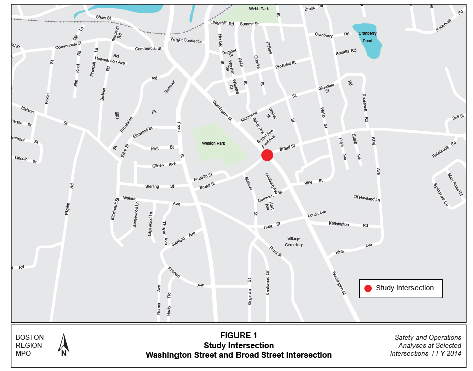
The location in Weymouth was selected because it has safety and traffic operations problems. Figure 1 shows the location of the intersection and the surrounding roadways.
An advisory task force comprising representatives from Weymouth was established to participate in this study. First, MPO staff met with the Weymouth Traffic Engineer, Mr. Owen MacDonald, at the intersection to discuss safety and operations issues and the scope of work for the study. MPO staff then met with the task force to present the existing conditions, problems identified, and proposed improvements. MPO staff addressed comments from the task force and incorporated them into this memorandum. Appendix A includes the list of task force members and comments about the study.
Route 53 is a predominantly two-lane, two-way arterial roadway that passes through eight communities from south to north: Kingston, Duxbury, Pembroke, Hanover, Norwell, Hingham, Weymouth, and Quincy. Although Route 53 is a state-numbered route, the portion north of Broad Street is locally controlled. The roadway, functionally classified as a principal arterial, is part of the National
Highway System (NHS) program and is eligible for federal funds provided for the program. In Weymouth, Route 53 is called Washington Street and it provides access to/from several locations in Weymouth as well as communities to the north and east of it.
Washington Street near the Broad Street intersection has right-of-way width of approximately 50-to-60 feet. It features five-to-six foot continuous and connected sidewalks on both sides, and a posted speed limit of 30 miles per hour (mph) in both directions. On-street parking is prohibited at the intersection. To the south of the intersection, Washington Street has a six-foot shoulder on each side of the roadway to accommodate bicyclists, and on-street parking is prohibited in this section. To the north of the intersection, Washington Street has no shoulder because on-street parking is allowed here—bicyclists share the roadway with motor vehicles. Two-hour parking is posted from 7 AM to 4:00 PM.
Broad Street is a town-owned roadway functionally classified as an urban minor arterial, a two-lane, two-way roadway that runs east/west. It is federal-aid eligible and qualifies for funds under the Surface Transportation Program. The right-of-way is approximately 40 feet wide and comprised of two 11-foot travel lanes, two- to four-foot-wide shoulders, and five-foot-wide continuous and connected sidewalk on both sides. The posted speed limit is 30 mph in both directions.
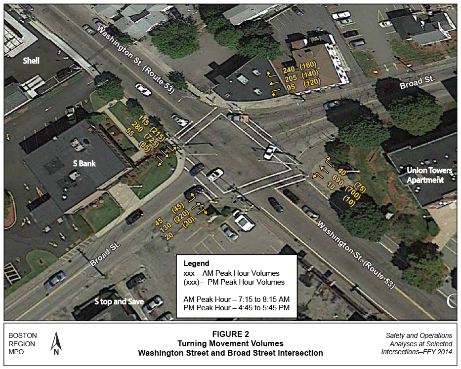
Washington Street and Broad Street forms a four-legged signalized intersection (Figure 2), with the primary traffic flow along Washington Street. Each approach on Washington Street widens to 23 feet approximately 175 feet prior to the intersection, and continues the same width through the intersection for approximately 175 feet past the intersection, but it is not striped as two travel lanes. Similarly, the westbound approach lane of Broad Street widens to approximately 22 feet for a distance of 100 feet prior to the intersection.
The intersection has traffic signal control but the signal equipment is outdated and may not have all of the functionality to operate efficiently. Pedestrian signals are functioning, well with adequate time for crossing the street curb to curb but they are not accessible pedestrian signals. Accessible pedestrian signals communicate information about the walk- and don’t-walk intervals in non-visual formats to pedestrians who are blind or who have low vision. In addition, the signal equipment lacks Opticom receivers to handle emergency services such as preemption of traffic queues. The signal heads are mast-arm mounted, however they lack backplates that would improve visibility.
There are crosswalks with curb ramps on all four legs of the intersection. The curb ramps lack detectable warning plates and cross slopes of some of them are too steep and do not comply with Americans with Disabilities Act (ADA) standards. The intersection curb radii are adequate for trucks and school buses servicing commercial/retail business and schools in the area.
The Massachusetts Bay Transportation Authority (MBTA) operates the Route 225 bus—Quincy Center-Weymouth Landing via Quincy Avenue and Shaw Street/Desmoines Road—within the study area. Route 225 has stops at the study intersection and connects commuter rail stations, major shopping centers, apartments, and schools. Route 225 operates Monday to Friday every 20 minutes from 5:30 AM to 11:57 PM; Saturday every 30 minutes from 6:30 AM to 11:56 PM; and Sunday every 60 minutes from 7:50 AM to 11:51 PM. MBTA buses are accessible to persons with disabilities. 5 In addition, some commuter rail riders who board the MBTA’s Greenbush Line at the Weymouth Landing/Braintree station go through the intersection to reach the train station.
The land use near the study intersection is mixed (residential, educational, and business). The S Bank, Stop and Save store, and Union Towers apartments are located at the intersection. In addition, the South Shore Christian Academy and Tufts Library are located on Broad Street, approximately 500 feet west of the intersection.
MPO staff collected traffic volume data to assess the operational characteristics of the study intersection (included in Appendix B). Staff collected turning-movement counts (TMCs) at the Washington Street and Broad Street intersection in April 2014 during weekday morning (7:00 to 9:00 AM) and evening (3:00 to 6:00 PM) peak travel periods. Pedestrian and bicycle counts were conducted simultaneously with the TMCs; heavy vehicles, including trucks, transit, and school buses were counted separately. Based on the counts, the estimated average daily traffic (ADT) on Washington Street was between 18,500-and-22,700 vehicles per day. The ADT on Broad Street ranged from 3,200 vehicles per day west of the intersection to 8,500 vehicles per day east of the intersection. Figure 2 shows the turning movement volumes at the intersection.
During the AM peak travel period, the primary traffic flow (peak direction) is northbound on Washington Street. In addition, a high volume of traffic southbound on Washington Street turns left onto Broad Street during the AM peak travel period. During the PM peak travel period, the primary traffic flow direction is reversed—southbound on Washington Street. Staff observed 66 pedestrians and 18 bicyclists crossing the intersection during the counting period. The percentage of trucks driving through the intersection during the AM and PM peak travel periods ranged between 3.0-and-4.0 percent, which is not considered high for peak-period traffic conditions. Staff did not detect any roadway geometry—such as turning radii, which would inhibit truck traffic flow—other than the peak-period congestion that affects all traffic.
The intersection is ranked 179th on the 2009–2011 Statewide Top-200 Intersection Crash List. Staff analyzed 2009–2012 crash records from the MassDOT Registry of Motor Vehicles (included in Appendix C). Crashes at the intersection form part of a Highway Safety Improvement Program (HSIP) crash cluster. This HSIP crash cluster is comprised of 55 crashes (including those near the Shell Gas Station), and 34 of which occurred at the intersection of Washington and Broad Streets. A summary of crashes at the intersection in terms of severity, manner of collision, weather conditions, ambient light conditions, and time of occurrence is presented in Table 1.
Staff calculated intersection crash rates per MassDOT Highway Division’s methodology, based on the entire four-year period. The most recent statewide average crash rate for signalized intersections in MassDOT Highway Division District 6, which includes the Town of Weymouth, is 0.76 crashes per million entering vehicles (mev). 6 The average crash rate of 0.84 mev for the study intersection exceeded that of a signalized intersection in District 6.
MPO staff used police crash reports obtained from the Weymouth Police Department to prepare a collision diagram that is useful for examining patterns and developing safety strategies. Figure 3 shows the collision diagram of the crashes. The numbers in the collision diagram uniquely identify each crash and, for more detail about the crash, may be used to cross reference the crash records provided in Appendix C. Prevalent crash patterns in the study area were rear-end-type crashes at the Washington Street approaches and Broad Street westbound approach and angle-type crashes involving Washington Street left-turn movements and opposing through movements. One-third of the crashes resulted in injury.
TABLE 1
Crash Summary (2009 to 2012)
Crash Variable |
Washington Street and Broad Street Intersection |
Crash Severity |
-- |
Non-fatal injury |
11 |
Property damage only |
21 |
Not reported/unknown |
2 |
Manner of Collision |
-- |
Angle |
16 |
Rear-end |
9 |
Sideswipe, same direction |
4 |
Sideswipe, opposite direction |
1 |
Single vehicle crash |
4 |
Road Surface Condition |
-- |
Dry |
25 |
Wet |
7 |
Snow |
2 |
Ambient Light Conditions |
-- |
Daylight |
21 |
Dark - lighted roadway |
12 |
Dusk |
1 |
Weather Conditions |
-- |
Clear |
22 |
Cloudy |
4 |
Rain |
6 |
Snow |
2 |
Travel Period |
-- |
Peak Period |
13 |
Off Peak |
21 |
Total Crashes (2009-2012) |
34 |
Four-year average (rounded) |
9 |
Average Crash Rate |
0.84 |
MassDOT Highway District 6 average crash rate for signalized intersection |
0.76 |
* The AM peak period is 7:00 AM to 9:00 AM, and the PM peak period is 4:00 PM to 6:00 PM.
Source: Central Transportation Planning Staff.
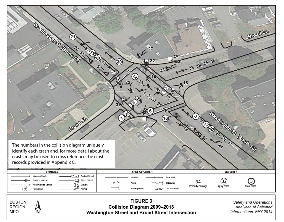
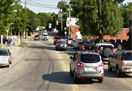
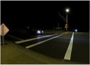
Most of the angle crashes on Washington Street resulted from failing to yield the right-of-way, following too closely, and not paying attention. In addition, the behavior of forming two travel lanes on Washington Street during peak travel periods and a single traffic lane during off-peak travel periods creates confusion for drivers, especially for those turning left onto Broad Street, as they do not see or expect a through vehicle to pass by a vehicle waiting to turn left in the opposing direction (Figure 4).
The absence of left-turn signal signs at the intersection also contributes to the angle-type crashes. For example, Washington Street southbound left-turn movements have a leading protected-left-turn, while northbound left-turn movements are permitted-left-turn; however, there are no traffic signal signs to convey this information to drivers. Another safety issue is driver awareness and visibility of the intersection because of the horizontal and vertical curvatures on Washington and Broad Streets.
FIGURE 4
Washington Street with Two Lanes of Traffic at the Intersection
Using the data and information collected, MPO staff built a traffic analysis network (with Synchro 7) for the AM and PM peak periods to assess the capacity and quality of traffic flow at the intersections. The analyses were conducted in a manner consistent with Highway Capacity Manual (HCM) methodologies (detailed worksheets of the analyses are included in Appendix D) 8. The HCM methodology demonstrates the driving conditions at signalized and unsignalized intersections in terms of levels of service (LOS) ratings A through F. LOS A represents the best operating conditions (little to no delay), while LOS F represents the worst operating conditions (very long delay). LOS E represents operating conditions at capacity (limit of acceptable delay). Table 2 shows the control delays associated with each LOS for signalized and unsignalized intersections.
TABLE 2
Levels of Service and Control Delays at Intersections
|
Signalized Intersections Control Delay |
Unsignalized Intersections Control Delay |
A |
≤ 10 |
≤ 10 |
B |
> 10-20 |
> 10-15 |
C |
> 20-35 |
> 15-25 |
D |
> 35-55 |
> 25-35 |
E |
> 55-80 |
> 35-50 |
F |
> 80 |
> 50 |
Source: Central Transportation Planning Staff.
Table 3 presents peak-hour performance in terms of LOS, delay, and queues for existing conditions. The intersection operates satisfactorily during the AM and PM peak periods (LOS D or better). Washington Street northbound and southbound movements currently operate at desirable LOS D during peak travel hours because of motorists forming two travel lanes to enter the intersection during peak periods. In addition, during PM peak hours there are queues on the Washington Street southbound approach that extend to Richmond Street. The large volume of traffic on Washington Street and absence of left-turn lanes make it difficult and unsafe for left-turning drivers to turn onto Broad Street. During the AM peak hour, traffic on the Broad Street westbound approach operates at LOS E with moderate queues; during the PM peak hour, traffic on Broad Street eastbound approach operates at LOS E.
TABLE 3
Washington Street and Broad Street Intersection,
Peak Hour Level of Service
| Improvement Alternative |
Move ment |
AM LOS |
AM Delaya |
AM Queueb |
PM LOS |
PM Delay |
PM Queue |
|---|---|---|---|---|---|---|---|
Existing Conditions (2014) |
-- |
-- |
-- |
-- |
-- |
-- |
-- |
Washington St. Northbound |
L+T+R |
B |
12.6 |
250 |
B |
16.5 |
267 |
Washington St. Southbound |
L+T+R |
B |
12.8 |
162 |
D |
43.8 |
#551 |
Broad St. Eastbound |
L+T+R |
D |
42.8 |
#262 |
E |
56.6 |
#378 |
Broad St. Westbound |
L+T |
E |
55.9 |
#404 |
D |
51.8 |
#333 |
Broad St. Westbound |
R |
D |
36.9 |
#286 |
D |
35.5 |
163 |
Total intersection |
All |
C |
25.5 |
-- |
D |
37.1 |
-- |
No-Build Conditions (2024) |
-- |
-- |
-- |
-- |
-- |
-- |
-- |
Washington St. Northbound |
L+T+R |
B |
12.9 |
266 |
B |
16.9 |
#285 |
Washington St. Southbound |
L+T+R |
B |
13.3 |
173 |
E |
60.2 |
#594 |
Broad St. Eastbound |
L+T+R |
D |
45.1 |
#281 |
E |
61.9 |
#402 |
Broad St. Westbound |
L+T+R |
E |
63.0 |
#428 |
E |
55.7 |
#354 |
Broad St. Westbound |
R |
D |
38.3 |
#306 |
D |
36.0 |
#171 |
Total intersection |
All |
C |
27.2 |
-- |
D |
44.9 |
-- |
Add Left-turn Lane with a Protected/Permissive Left-Turn Phase on Southbound Washington Street (2024) |
-- |
-- |
-- |
-- |
-- |
-- |
-- |
Washington St. Northbound |
L+T+R |
C |
28.9 |
#393 |
C |
27.2 |
#415 |
Washington St. Southbound |
L |
C |
24.0 |
#118 |
D |
35.4 |
#256 |
Washington St. Southbound |
T+R |
B |
17.5 |
280 |
D |
36.7 |
#907 |
Broad St. Eastbound |
L+T+R |
C |
25.9 |
196 |
D |
36.6 |
#364 |
Broad St. Westbound |
L+T |
C |
33.1 |
#366 |
D |
52.8 |
#370 |
Broad St. Westbound |
R |
C |
27.5 |
241 |
C |
27.7 |
165 |
Total intersection |
All |
C |
26.8 |
-- |
C |
34.7 |
-- |
Add Left-turn Lane with a Protected Only Left-Turn Phase on Southbound Washington Street (2024) |
-- |
-- |
-- |
-- |
-- |
-- |
-- |
Washington St. Northbound |
L+T+R |
D |
40.6 |
#421 |
E |
72.2 |
#467 |
Washington St. Southbound |
L |
D |
49.8 |
#177 |
E |
58.8 |
#301 |
Washington St. Southbound |
T+R |
B |
16.8 |
267 |
D |
38.5 |
#854 |
Broad St. Eastbound |
L+T+R |
C |
24.7 |
185 |
D |
39.0 |
#361 |
Broad St. Westbound |
L+T |
C |
33.0 |
#354 |
E |
60.8 |
#356 |
Broad St. Westbound |
R |
C |
26.6 |
#250 |
C |
26.4 |
156 |
Total intersection |
All |
C |
32.5 |
-- |
D |
52.4 |
-- |
a Delay in seconds per vehicle. b 95th percentile queue length in feet. # = The 95th percentile volume exceeds capacity.
Source: Central Transportation Planning Staff.
Based on existing conditions, analysis of traffic and crash data, field reconnaissance, and discussions with the town officials, staff identified the following problems:
Staff used a planning model to forecast future traffic-volume changes systematically that could result from changes in the transportation network or land use. The model used in this study is the Boston Region MPO’s most recently adopted regional travel demand model set used for the Long-Range Transportation Plan. Its socioeconomic components are based on forecasts produced by the Metropolitan Area Planning Council. Using TransCAD software, the model is calibrated at a regional level for 164 cities and towns, including all 101 cities and towns in the MPO region. Based on this regional planning model, traffic on Washington Street is expected to grow at 0.4 percent per year, which results in total growth of 5 percent between 2014 and 2024.
MPO staff developed and analyzed short- and long-term strategies to improve safety and traffic operations at the study intersection. The projected growth factor from the regional model set was used to expand existing peak-hour turning-movement volumes to 2024 future turning-movement volumes for testing the improvement strategies.
The list below addresses low-cost improvements for safety and operations that involve repairing, replacing, or installing minor geometric elements such as curb ramps, signage, and pavement markings. The suggested improvements could be implemented in phases depending on the urgency of the problem.
Source: Manual on Uniform Traffic Control Devices for Streets and Highways, U.S. Department of Transportation, Federal Highway Administration, 2009 Edition
Source: safety.fhwa.dot.gov
Estimated effectiveness of pedestrian safety improvements: 9
Estimated cost to implement safety improvements for pedestrians is approximately $50,000 (including curb ramps, accessible pedestrian signals, illumination, countdown timers, and high-visibility crosswalks)
Source: https://ladotbikeblog.wordpress.com/bfs/ and https://beaconarts.org/
The results of the 2024 future year analysis presented in Table 3 show that reconfiguring approach lanes would improve traffic operations; the intersection would operate at LOS C during the AM peak hour and LOS D during the PM peak hour. Estimates of the efficacy of providing a left-turn lane on one major road approach suggest a 24-to-44 percent reduction in all crashes.10 It would cost approximately $20,000 to implement the improvements, including lane stripping, new signal heads for left-turn movements, new signal timings, and signs.


Source: Manual on Uniform Traffic Control Devices for Streets and Highways, U.S. Department of Transportation, Federal Highway Administration, 2009 Edition
Installing left-turn signs suggests a 9-to-29 percent reduction in left-turn related crashes;11 installing advance traffic control signs suggests as much as a 35-percent decrease in crashes; installing backplates suggests as much as a 15-percent reduction in crashes. It would cost approximately $10,000 to implement the improvements.
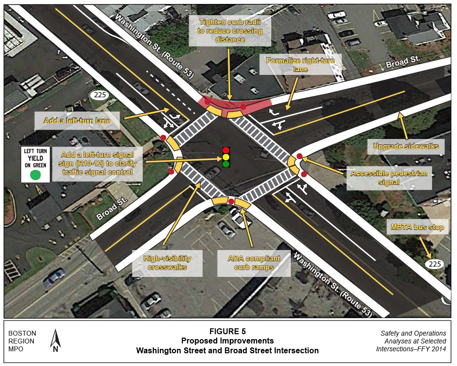
Because long-term improvements involve engineering and design work, they generally cost more than short-term improvements, and take from five-to-ten years to implement. A logical and cost-effective strategy for the improving the intersection would be a complete renovation (Figure 5), which would include the following:
The design year (2024) analysis results are presented in Table 3 above for a protected/permissive phase and a protected-only phase for Washington Street southbound left turns. The analyses show that traffic would operate at LOS D or better during the AM and PM peak travel periods for a protected/permissive left-turn phase. The analysis show that with a protected-only left phase, traffic would operate at LOS D during the AM peak travel period and LOS E during the PM peak travel periods. Reconstructing the intersection suggests as much as an 80-percent reduction in total crashes may be expected.12 The reconstruction should cost approximately $1.5-to-2.0 million.
The above analyses and evaluation indicates that the intersection of Washington Street and Broad Street needs enhancements to improve safety and mobility for motorists, pedestrians, and bicyclists MPO staff recommends a total reconstruction of the intersection because of the many safety and operations improvements needed there. Weymouth officials concur with this recommendation. However, implementing some of the low-cost short-term improvements, such as converting standard crosswalk markings to high-visibility markings, reconstructing curb ramps to ADA standards, and clarifying signal control would provide immediate benefits.
This study gives Weymouth an opportunity to look at the needs of the intersection and plan for design and engineering. Next steps would be to implement the preferred low-cost, short-term improvements. Implementation of the long-term, high-cost improvements hinge upon cooperation between MassDOT, Weymouth and the MPO to begin the project notification and review process, complete project initiation form, and start preliminary design and engineering to place the project on the Transportation Improvement Program(TIP). MassDOT project development process is included in Appendix E. This study also supports the MPO’s visions and goals, which include increasing transportation safety, maintaining the transportation system, and advancing mobility, access, and congestion reduction.
SA/sa
cc: Raj Kulen, Traffic Engineer, MassDOT Highway Division, District 6
1 Seth Asante, memorandum to Boston Region MPO, Safety and Operations Analyses at Selected Intersections—FFY 2013, Task 1: Intersection Selection Procedure, December 19, 2013.
2 Transit Significance: Location carries bus route(s) or is adjacent to a transit stop or station.
3 Regional Significance: Location carries high proportion of regional traffic or noticeable commuter bicycle traffic.
4 Implementation Potential: Location either is under MassDOT jurisdiction, has a Transportation Improvement Program (TIP) “conceptual” status, or a strong commitment from a city or town
5 Massachusetts Bay Transportation Authority, Bus Schedule, Effective March 21, 2015, http://www.mbta.com/schedules_and_maps/bus/routes/?route=225
6 Based on MassDOT Registry of Motor Vehicles crash information queried on January 23, 2013.
7 Trafficware Inc., Synchro Studio 8, Synchro plus SimTraffic, Build 801, Version 563, Sugar Land, Texas.
8 Highway Capacity Manual, HCM 2010, Volume 3: Interrupted Flow, Transportation Research Board of the National Academies, Washington DC, December 2010.
9 Crash Modification Factors Clearinghouse, US Department of Transportation Federal Highway Administration.
10 Ibid.
11 Ibid.
12 Crash Modification Factors Clearinghouse, U.S. Department of Transportation Federal Highway Administration.